Haines Highway / Lutak Road Project
Project Description
Official Project Name: Haines Hwy / Lutak Road - Dec 20 SE PR
State Project No: 0093007 / SFHWY00446
A project in the DOT&PF 2020 Storm Recovery Program
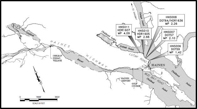
Figure 1. Project Vicinity Map
Project Overview
The Alaska Department of Transportation and Public Facilities (DOT&PF) is repairing several sites damaged in the 2020 Storm in Haines, Alaska.
Purpose & Need
In December 2020, a week of record rainfall in Southeast Alaska led to widespread flooding and landslides in local communities. By the end of the storm, Alaska Department of Transportation and Public Facilities (DOT&PF) roads in Juneau, Haines, Skagway, Hoonah, and Petersburg had sustained widespread damage. DOT&PF conducted immediate emergency repairs on numerous sites to address roadway damage, washed out culverts, filled drainage ditches, and landslides. Permanent repairs are required to rebuild Alaska’s infrastructure.
The purpose of this project is to repair infrastructure that was damaged by the December 2020 Storm event.
Project Description
This project includes multiple locations requiring grading, drainage, guardrail, and rock facing along Haines Highway / Lutak Road between mile points (MPt) 0.5 and 4.3. The project will design and make permanent repairs to the damaged culverts, restabilize rock slopes, replace the damaged headwall, and reconstruct a section of guardrail. These will address damage and related challenges with grading, drainage, slope stabilization, and embankment stability.
The proposed repairs are not anticipated to impact the existing paved road surface, and the existing lane and shoulder widths will be maintained. Repairs at Milepost (MP) 2.98 will involve reconstruction of the embankment foreslope around the displaced headwall. No planned improvements to the road widths, grades, foreslopes, ditches, or backslopes are planned for the other locations included in this project.
Changes or improvements to the existing roadway geometry are not within the project scope due to FEMA requirements that permanent repairs return the infrastructure to pre-storm conditions. Therefore, horizontal and vertical alignments will match their pre-storm event dimensions.
The following describes the proposed improvements by each location.
HNS006 - 1.42:
The MP 1.42 site is located just north of Portage Cove at the base of a steep slope that extends up to approximately 350 feet above the road. The proposed repair includes construction of a rock inlay with a concrete toe berm and scaling of loose rock. The repair is anticipated to require construction of a temporary access ramp.
HNS007 - MP 2.10: The MP 2.1 site is located 2.2 miles southeast of the Haines Ferry Terminal. The proposed repair will involve scaling of loose and unstable rock blocks on the rock slope face with installation of pinned mesh reinforcement on the upper soil slope.
HNS008 - MP 2.26: The proposed repair will remove the ends of two culverts projecting from a concrete headwall at the pipe inlets. The damaged pipe segments will be cut flush with the face of the headwall.
HNS010 - MP 2.98:
The proposed repair is to replace the displaced headwall with a new headwall at the outlet of the existing culvert. The repairs include restabilizing the embankment around the culvert outlet.
HNS011 - MP 4.07:
The proposed repair is to remove the damaged guardrail and install new guardrail. A cost-benefit analysis was completed to evaluate permanent geotechnical and drainage improvements above Lutak Road and the Ferry Terminal to stabilize slopes and reduce the potential for future storm events to impact the State facilities. Due to the estimated costs and right-of-way (ROW) impacts associated with conceptual design alternatives, the permanent improvements above Lutak Road were not advanced as part of this project.
Project History
Lutak Road is a local road serving the community of Haines. The 2022 AADT was 370 vehicles per day (VPD) between the ferry terminal and Salmon Run Campground, 330 VPD between Salmon Run Campground and Chilkoot Lake Road, and 90 VPD between Chilkoot Lake Road and the end of the road.
HNS006 - Milepost (MP) 1.42:
The 2020 storm event overburden soils, loose rock and organic debris to overwhelm the roadway ditch and partially block the southbound travel lane. Emergency repairs opened up the lane and temporarily stabilized the slope.
HNS007 - MP 2.10: The 2020 storm caused overburden soils from the top of cut to flow into and overwhelm the roadway ditch.
HNS008 - MP 2.26: Following the 2020 storm, the debris was approximately 12 feet deep over the road. The storm flows eroded a roughly 4-foot vertical drop off the edge of pavement on the downstream side, exposing the top of the culverts along the downstream edge of the road. The culvert inlets were damaged during removal of material deposited during the 2020 storm event.
HNS010 - MP 2.98:
Erosion at the culvert outlet during the 2020 storm undermined the concrete headwall and caused the headwall to settle and separate from the culvert. The existing headwall slumped away from the culvert due to erosion caused by storm surge and high flows during the 2020 storm event. Erosion has continued since the headwall separated from the culvert. The outlet is located on the beach of the Chilkoot Inlet and is within the influence of the extreme high tide. This beach location has a southern exposure and is hit by strong waves during storms.
HNS011 - MP 4.09:
Guardrail was damaged during the 2020 storm.
Status
The project will be under construction July through September 2026.
Temporary Traffic Disruptions
The project will seek to keep one lane open throughout construction with the possible exception of short temporary closures for paving.
DOT&PF will coordinate with the Haines Borough to develop a traffic control plan that minimizes impacts to residents and businesses, particularly during the tourist season, and safely guides and protects the traveling public in work zones.

Use DOT&PF's Alaska Project Exchange tools to learn more about all of DOT&PF's active construction projects statewide!

